

Special pages:
Pmaps Documentation
Table of contents
This pages are the manual of this application.
About Pmaps
The application retrieves GIS data from geoserver and renders it on maps in an end user friendly manner. Further the user can collect data connected to GIS objects registered in geoserver before.
The collected data can also be statistically analysed and visualised. Certain data can spark alarms for GIS objects.
The Installation process
As mentioned before the underlaying operating system offers a package management, that allows to install and set up the most important components easily. Since we need some more flexibility regarding Geoserver, we will not use that management system for our GIS component.
Step one: OS Installation and setup
We use the stable branch of Debian GNU Linux .
The following server components are set up and running by default:
- SSH (for remote operation via internet or local net at port 22, provides secure filetransfer via SFTP also)
- HTTPD (the webserver Apache listening at port 448)
- MariaDB (internal SQL database RDBMS for use with the Application)
- PostGreSQL (internal SQL database RDBMS for use with Geoserver only)
- PHP module for Apache including several extensions
Step two: Geoserver Installation
As mentioned above we install Geoserver from the Platform Independent Binary Package available on the projects website at geoserver.org
The package is extracted and configured in the filesystem at path adress /home/ungeo/geoserver "ungeo" is the default username for the system, it is also used for login to the system via network(ssh protocol).
Further geoserver is set up as a system service using the systemctl command used by Debian and all modern Linux distributions to manage and control system services.
The Platform Independent Binary Package comes with the Java based webserver component Jetty, please be aware, that the Tomcat Applet Server, that is used by many other installation methods of Geoserver is not used and should not be installed in order to avoid conflicts. As the geoserver service is started, Jetty offers connection to it at port 8080, like so: http://swap-amhara.org:8080/geoserver.
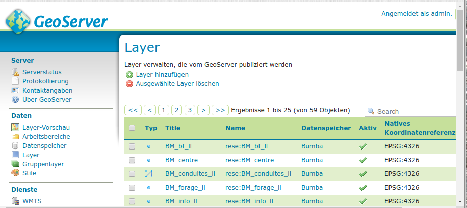
Geoserver running at http://swap-amhara.org:8080/geoserver
Step three: Installation of the Application
ProjectMaps is a PHP based webapplication, it is installed as a range of plain folders and files into a place accessible by the apache webserver. That is in our case /home/ungeo/amhara. This adress is set up in Apaches configuration files as the default website to be delivered, if any client asks for a connection to port 80 and 448.
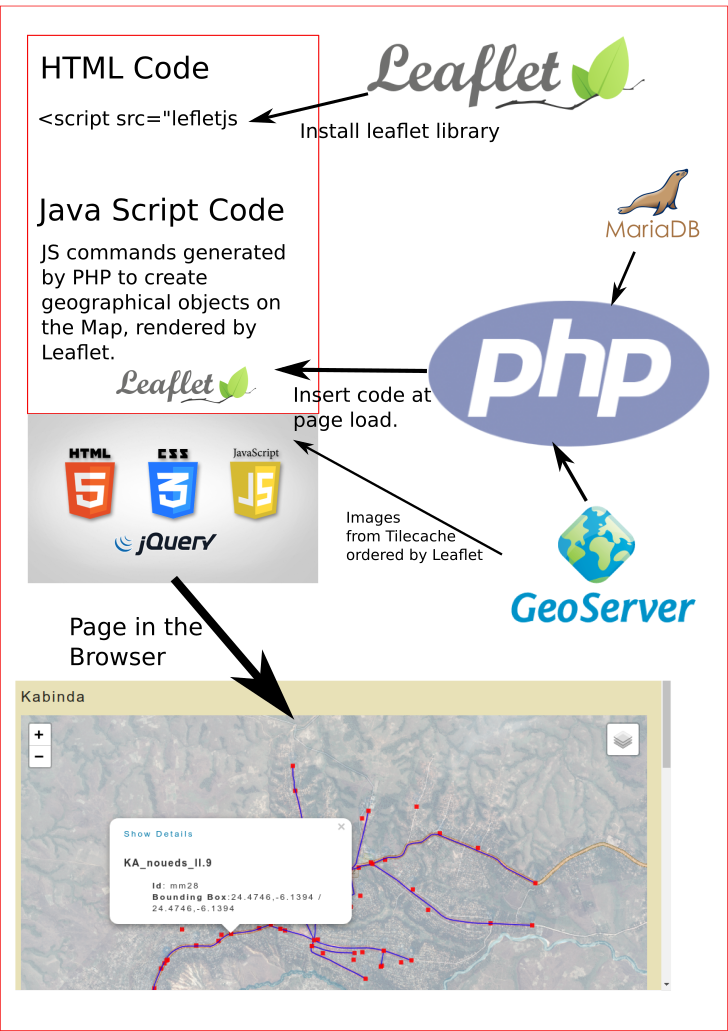
The Leaflet map software is integrated in the Application, stored in subfolders of /home/ungeo/amhara/addons/js and called as needed in the header of the HTML page, that the PHP system delivers at users request. The leaflet software is downloaded to the users computer and executed in his or her browsers context.
How we draw the map with Leaflet
Development Documentation
Descriptions of functions, database layout and all that other API stuff
Amhara Dashboard: Data sources and algorithms to compute figures
Total of trees planted
- Sources: GIS:pl_sche,pl_bou,bou_area_sin
Algorithm:
Basics:
pm_amhara_stats->compute_totpltrs()
create arrays for each year with slots for each woreda
iterate pl_scheData['features'] and scan for: ['properties']["spec"]
compute surface($wholeSurf) for each spec(heco, fagrow, ind)
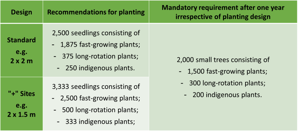
    if($feat['properties']["spec"]=="heco"){
     if(isset($this->bouPlotsSurf[$puic])){
      $wholeSurf=$this->bouPlotsSurf[$puic];
       $this->totalSurfheco+=$wholeSurf;
      //NOW: compute the numbers of trees per class
      if (standard class){

        $wantTreesPerha=2500;
        $wantTrees=$wantTreesPerha/$wholeSurf;
        $indRatio=$wantTrees/250;
        $indFactor=$wholeSurf/$indRatio;
        $lRRatio=$wantTrees/375;
        $lRFactor=$wholeSurf/$lRRatio;

       $t[$y]['ind']+=$indFactor*$wholeSurf;
       $t[$y]['lr']+=$lRFactor*$wholeSurf;
       $this->totalSurfhecoClass1+=$wholeSurf;
       if($zone !== "na"){
        $t[$y][$zone]+=$indFactor*$wholeSurf+$lRFactor*$wholeSurf;
       }
      }

      if ("+" class){
        $wantTreesPerha=3333;
        $wantTrees=$wantTreesPerha/$wholeSurf;
        $indRatio=$wantTrees/333;
        $indFactor=$wholeSurf/$indRatio;
        $lRRatio=$wantTrees/500;
        $lRFactor=$wholeSurf/$lRRatio;

       $t[$y]['ind']+=$indFactor*$wantTreesPerha;
       $t[$y]['lr']+=$lRFactor*$wantTreesPerha;
       $this->totalSurfhecoClass1+=$wholeSurf;
       if($zone !== "na"){
        $t[$y][$zone]+=$indFactor*$wholeSurf+$lRFactor*$wholeSurf;
       }
      }
    }

     }//END if heco

     //similar for fast grow

     if($feat['properties']["spec"]=="fagro"){
       $this->totalSurffagro+=$srf;
      if (standard class){
       $wantTreesPerha=2500;
        $wantTrees=$wantTreesPerha/$wholeSurf;
        $fagroRatio=$wantTrees/1875;
        $fagroFactor=$wholeSurf/$fagroRatio;
       $t[$y]['fg']+=$fagroFactor*$wantTreesPerha;
       $this->totalSurffagroClass1+=$wholeSurf;
       if($zone !== "na"){
        $t[$y][$zone]+=$fagroFactor*$wantTreesPerha;
       }
      }
      if ("+" class){
       $wantTreesPerha=3333;
        $wantTrees=$wantTreesPerha/$wholeSurf;
        $fagroRatio=$wantTrees/2500;
        $fagroFactor=$wholeSurf/$fagroRatio;
       $t[$y]['fg']+=$fagroFactor*$wantTreesPerha;
       $this->totalSurffagroClass1+=$wholeSurf;
       if($zone !== "na"){
        $t[$y][$zone]+=$fagroFactor*$wantTreesPerha;
       }
      }
     }//END if fagro
Total of plots
- Sources: GIS:pl_bou
Algorithm:
pm_amhara_stats->compute_totpl()
create arrays for each year
iterate pl_bouData increase number per year for planted year in array
Total of ha GIS
- Sources: GIS:pl_bou
Algorithm:
pm_amhara_stats->compute_totha()
create arrays for each year
iterate pl_bouData add surface figure per year for planted year in array
Total of beneficiaries
- Sources: GIS:bou_area_sin
Algorithm:
pm_amhara_stats->compute_totmem()
Create Array for years and woredas: $pairs[2020][$woreda]
iterate bou_area_sinData['features'] and
add ['properties']['no_mem'] to found woreda in the given UIC of the GIS entry per planted year
Total Payments
- Sources: DB:ODKLegacyData, DB:ImportFromKobo(NIY)
Algorithm:
get figures for 1st/2nd payment from DB
iterate all entries and
increase sums per Woreda(as registered in entry)TODO:
include kobo data
solve problems with misspelled woreda names
determine what entries are legit and complete
Trees planted until last year
- Sources: GIS:pl_sche, pl_bou
Algorithm:
fetch results from Total of trees planted Algorithm
Summarize and list total and per woreda
Trees planted by Woreda
- Sources:GIS:pl_sche, pl_bou
Algorithm:
fetch results from Total of trees planted Algorithm
Summarize and list per woreda
Number of plots by Woreda
- Sources: GIS:pl_bou
Algorithm:
Create array with registered woredas
Count plot entries per woreda
Number of ha by Woreda
- Sources: GIS:
Algorithm:
Create array with registered woredas
Summarize ['properties']['surf'] per woreda
Tree species by categories
- Sources: GIS:pl_sche,pl_bou,bou_area_sin
Algorithm:
fetch results from Total of trees planted Algorithm
summarize tree species numbers
How to control access to uploaded documents
A document is a collection of several data sets. In most cases the core data will be a file. Files are stored on the server under
/home/ungeo/to/uploads
While uploading a file the function pm_libs/pm_tools.php:pm_generic_store_file() processes the data sent by the upload form. It also checks the current date and puts the file to upload in a subfolder of uploads named with the current year and month.
Thus a file uploaded today would be stored under:
/home/ungeo/to/uploads/2020/07
Supplemental information and the file address will be stored in the data base table pm_files.
This files table is not shown directly in the portal, it is connected to the data set for a document. This data set, stored in pm_documents, is listed in http://at2er-portail.org/?pm_view=pm_doc&pm_section=pm_nat_nav.
The form for the upload is to be found in pm_libs/pm_forms.php:pm_form_fileup()
The document data set
Table structure:
| Field | Type | Null | Key | Default | Extra | |
|---|---|---|---|---|---|---|
| did | int(8) | NO | PRI | NULL | auto_increment | |
| type | int(3) | NO | NULL | |||
| title | varchar(1024) | NO | NULL | |||
| description | text | NO | NULL | |||
| author | int(8) | NO | NULL | |||
| authorship_remarks | varchar(2048) | NO | NULL | |||
| institution | varchar(1024) | NO | NULL | |||
| publication_time_place | varchar(1024) | NO | NULL | |||
| volume | varchar(32) | NO | NULL | |||
| version | varchar(256) | NO | NULL | |||
| availability | int(4) | NO | NULL | |||
| creator | int(8) | NO | NULL | |||
| date | int(12) | NO | NULL | |||
| ressource | int(8) | NO | NULL | |||
| status | int(8) | NO | NULL |
The value to control access is the number stored in the field availability.
The numbers in that field are defined in the table pm_attributes.
aid name desription type status parent
31 public 	... 	8 	2 	0
32 internal ... 	8 	2 	31
33 Internal ... 	8 	2 	31
34 admin 	... 	8 	2 	31
The pm_attributes holds several attribute data sets and can be extended as needed. The key value is type. The form to upload documents reads the type 8 and lists its results ordered by parent. The parent is the leading entry for the attribute list, the other entries are connected by the parent.
The ID of the attribute, named aid is the value for availability in the pm_documents table.
What do we have?
- We know, what an attribute of type 8 means: availability.
- That attribute is offered by the upload form to tag a document with it.
- We can restrict the access to each document based on that number, that is available in every document dataset.
How to implement restrictions
Every user in the portal has a data set in pm_users. The field status holds a number from 0 to 10. Number 10 means Administrator(no restrictions) 0 would be User is suspended.
That status code is available for every user logged in to the portal.
This is your current data set:
This array is an ordered data set, its fields can be read individually. If you want to know about the status value, use the following code:
echo $pm_user[0]['status'];
For convenience the system reads that value at login into a single variable.
echo $pm_user_status;
Shows for you:
You are not logged in
Thus we have that status value for the current user. We can use it when we list the documents to decide, what documents the current user shall see or not. The status can also be called a score.
We can make that decision at every point, the document is read. For now we have this in pm_custom_templates/pm_doc/pm_docs.php:
   if (isset($doc_data['document'])){
    $avail=$doc_data['document'][0]['availability'];
    //based on avail we can decide, who may see the file by using the score of the logged in user account
    //show everything for admin
     if ($pm_user_status >8){
      pm_show_single_document ($doc_data,$pm_show_options);
     }
     elseif ($pm_user_status < 8 and $pm_user_status > 4){
      if ($avail != 34){
       pm_show_single_document ($doc_data,$pm_show_options);
      }
     }
     elseif ($pm_user_status < 5 and $pm_user_status > 1){
      if ($avail != 34 and $avail!= 33){
       pm_show_single_document ($doc_data,$pm_show_options);
      }
     }
    }
As you see: first we check, if the document dataset is read correctly, then we can be quite sure, that the availability field holds usable data. Documents, that have undefined data at that field, shall be ignored in the portal.
Whoever has more than score/status 8 every document is shown, lesser status means stronger filtering.
Wherever a document is read or shown, this status/score value can be used to restrict reading and listing of any given single document.
Working with GIS data: SLD Styles
Background: how SLD works
SLD is basically a list of styling rules in a XML tree. Similar to CSS but with the important feature to be independant from a given Document Object Model(DOM) to select objects, that shall be styled.
In SLD the pointers to the objects are directly programmable, thus the SLD does not depend on predefined structures in the GIS layer, that shall be styled, but allows for direct styling commands to arbitrary elements of the layer, usually defined in a SHP file.
A Geographer working with say: QGIS, may select the elements in a layer and give it the tag "STATUS", for each feature of that element, the field "STATUS" may have differend values such as "Existant" or "Planned". The specialist can now determine in SLD, that a feature with STATUS=Existant shall be drawn in dark green, a feature with STATUS=Planned shall be drawn in light yellow etc.
The software, that draws the map, needst to implement these rules in any way its developers see fit. Based on the rules of the XML format and ... well: Logic.
This is where the work begins for us:
How SLD is read in the portal software
- Connect the layer to a given SLD file
- Read the SLD file while processing the layer
- Apply the extracted rules to the Java Scrip code, that is passed to Leaflet to draw the layer
Step 1 is done wherever you want to draw a layer onto a map. You need the store, where the layer is registerd in GIS, the name of the layer and the name of the SLD file(the path to the file is standardised als /sld/sld/ and does not need to be used in the code, that invokes the layer).
At the point, where you want the JS for Leaflet to be rendered, you use the function /pm_libs/pm_tools.php:pm_make_leafletgisobjects_byrequest($pm_gis_layers_features,$pm_store_name,$pm_style,$options)
The Argument $pm_style can be used, to apply primitive styles such as color if you do not SLD, behold: ProjectMaps Software is friendly and forgiving ;-)
The SLD can be connected by the Argument $options.
Please be aware, that $options has to be an array, even if you pass only one value...
if (isset($options['sld'])){
Asks, if you have passed the option $options['sld'] when calling the function, its value needs to be a name of an sld file stored in /sld/sld/ . The file needs to exist and be readable by the webserver, feel free to implement further checks for that to avoid ugly error messages and dysfunctional maps in case the file is not available(deleted by you cat or not uploaded already or being named "MySLD.sld" instead "mySld.sld").
If the option is passed to the function the File is read and processed:
 if (isset($options['sld'])){

  $sld_file_source=$options['sld'];
  $section=$options['sld_section'];
  $sld_rules_digest=pm_sld2array($sld_file_source,$section);

 }
As you see, the processing demands you to pass another option: $options['sld_section']. This will be in most cases the sld_section "Rule" the interface allows you, to select other sections as well if needed, but for now, it demands you to name the wanted section explicitly. So the correct code to call the function could be like seen in the National Map (/pm_templates/pm_gis/pm_nat_map.php):
 elseif($layer_name=="reseau_ht"){
  $color="#df0808";
  $options['sld']="reseau_ht.sld";
  $options['sld_section']="Rule";
 }

 //[...some other code...]

 $pm_gis_layer_features[0]=pm_get_gis_features($layer_name);

 $pm_LayerGroup=pm_make_leafletgisobjects_byrequest($pm_gis_layer_features,$pm_store,$color,$options);
The function pm_get_gis_features($layer_name) gets the list of features for layer_name. The layer_name is taken from a list of layers, that shall be drawn on the map. Important: the options need to be individual for each layer in that list, therefore the elseif ($layer_name=="reseau_ht"): we want the SLD file reseau_ht.sld applied to that layer only, not to every given layer.
Back to pm_make_leafletgisobjects_byrequest:
If the options are passed properly, the file $options['sld'] will be read by a helper function:
$sld_rules_digest=pm_sld2array($sld_file_source,$section);
This function splits the SLD file in 3 parts, the second of these parts holds the Rule elements of its XML tree. To this part a XML parser built into PHP is applied. It returns the subelements of every Rule as a section of an array, that can be processed in PHP.
In order to get the results, as demanded in the SLD file, we need to implement the logic in the SLD in the PHP code of pm_make_leafletgisobjects_byrequest.
How to translate the demands in SLD to Java Script code for Leaflet
All this is done in pm_make_leafletgisobjects_byrequest, here we have now the digest of the rules set in the SLD, we need to implement the logic as defined by the Geographer in the SLD, that is now available as a PHP array by the name of $sld_rules_digest:
$sld_rules_digest=pm_sld2array($sld_file_source,$section);

//[...some other code...]

if(is_array($pm_gis_layers_features)){
 //read all features of the layers passed to function
 foreach($pm_gis_layers_features as $pm_feature_info){

  $layer_objects="";
  $gisoid_number=0;

   if(is_array($pm_feature_info)){
  foreach($pm_feature_info['features'] as $feature){

   $fields="";
   $icon="smallIcon";
   $icon_file="";
   $pm_sld_icon_png="";
   if (isset($options['icon'])){
    $icon=$options['icon'];
   }
   $pm_gis_head="";

   foreach($feature['properties'] as $fieldname => $val){
    //properties is the realm that has to be checked for filtering

    if (isset($sld_rules_digest)){

     if ($fieldname == "Situation"){

      $sld_ruled_color=explode(":",$sld_rules_digest[$val][0]);
      $sld_ruled_width=explode(":",$sld_rules_digest[$val][1]);
      $pm_style=$sld_ruled_color[1];
      $pm_width=$sld_ruled_width[1];

     }
     if ($fieldname == "STATUS"){

      $sld_ruled_color=explode(":",$sld_rules_digest[$val][0]);
      $sld_ruled_width=explode(":",$sld_rules_digest[$val][1]);
      $pm_style=$sld_ruled_color[1];
      $pm_width=$sld_ruled_width[1];

     }
     if ($fieldname == "Mehh"){

      $sld_ruled_color=explode(":",$sld_rules_digest[$val][0]);
      $sld_ruled_width=explode(":",$sld_rules_digest[$val][1]);
      $pm_style=$sld_ruled_color[1];
      $pm_width=$sld_ruled_width[1];

     }
     if ($fieldname == "Single symbol"){
      $sld_ruled_fill=explode(":",$sld_rules_digest[$val][0]);
      $sld_ruled_color=explode(":",$sld_rules_digest[$val][1]);
      $sld_ruled_width=explode(":",$sld_rules_digest[$val][2]);
      $pm_fill=$sld_ruled_fill[1];
      $pm_style=$sld_ruled_color[1];
      $pm_width=$sld_ruled_width[1];

     }
     if (isset($sld_rules_digest['Single symbol']['ExternalGraphic'])){
      //this is only the SVG as usually put into the sld by QGis, need to find the PNG by that
       $pm_sld_icon_svg=$sld_rules_digest['Single symbol']['ExternalGraphic'];
       $icon_file="sld/svg/"."$pm_sld_icon_svg".".png";
       if (is_file($icon_file)){
        $pm_sld_icon_png="sld/svg/"."$pm_sld_icon_svg".".png";

       }
      }
    }//End if isset sld rules digest
   }
 }
}
Explanation:
- Line 15 - 22: we set default values, that are used, if the SLD rules do not demand other values.
- Line 24: Every property in the Shapefile is read and its field name and value are stored in 2 variables.
- Line 27: The SLD rules are processed only, if they are successfully read from the SLD file
- Line 29: This is the point of the logical connection: if the name of the field in SHP, that is read, is a ogc:PropertyName in the SLD-XML, a temporary array is created with the PHP function explode, that takes the corresponding entry from the $sld_rules_digest.
The next step is to read the value set in the SLD from the digest into a single variable, that will be used in the JS code for Leaflet.
All that code is processed for each property in the features in that layer. Only, if there is the match field name in SHP == ogc:PropertyName the value is read and overwrites the defaults for $pm_style and $pm_width to set color and width of a vector line on the map. - Line 53: Single symbol is a standard property name in SLD, it allows to set SVG Icons on the map, we do not use that for now...
- Line 64: if however, the Single symbol has a subelement ExternalGraphic, then we can find and use a icon file as known from the training site. Plese remember, that that file needs to be created and uploaded to the svg-folder by you, it is not available automatically.
If you need to implement another rule in a new SLD file, just insert a new code block like this:
     if ($fieldname == "NewSHPProperty"){

      $sld_ruled_color=explode(":",$sld_rules_digest[$val][0]);
      $sld_ruled_width=explode(":",$sld_rules_digest[$val][1]);
      $pm_style=$sld_ruled_color[1];
      $pm_width=$sld_ruled_width[1];

     }
If the NewSHPProperty is in the SHP processed by the code above, its style as defined in the corresponding SLD will be found and applied like so:
     var tube<?php echo $gisID_stripped?> = new L.Polygon(latLonExtraVectors<?php echo $gisoid_number?>, {
      <?php if (isset($options['noclick'])){ echo "interactive:false, ";} ?>
      color: '<?php echo $pm_style;?>',
      weight: 2,
      opacity: 0.4,
      fillColor:'<?php echo $pm_fill;?>' ,
      fillOpacity: 0.1,
      smoothFactor: 1
     });
Comments:
Fatal error: Cannot declare class pm_gis_reader, because the name is already in use in /home/ungeo/amhara/pm_libs/pm_gis_reader.php on line 7